If you enjoy reading this blog, you may also like to read my Dr. Bill Tells Ancestor Stories blog. You can also read about the family stories in my novels at The Homeplace Series blog. You can sign up for e-mail reminders.

Sunday, June 16, 2013

Notom, Utah, area from field trip - more photos


Notom, Utah, area from field trip - more photos


As I first reported in my post of our field trip to Notom and other sites on Tuesday, this will be the first of two followup posts. The second will be a Tombstone Tuesday post on this coming Tuesday on the Notom Cemetery, itself.

You can see the Notom Ranch Bed & Breakfast in the distance over the rear part of the Jeep. It is about the only 'public place' now in the area. The distinctive rock formations even further to the far rear are the Waterpocket Fold formations - from the south, not normally seen - of the Capital Reek National Park. I encourage you to check the links, if only briefly, to get a 'feel' for the area we are in.

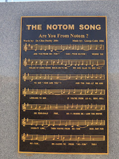
This Notom sign, it self, is notable. Here is a better view:


The left panal has a history of the area:


The right panel has the tune and words of a favorite song of the area, "Art You From Notom?":


The center panel honors the Durfey family and their military service.

Perhaps a few hundred feet or so, from the sign, to the left as you look at it, are some relics of the early years of Notom:


Annette is sitting on the old tractor...behind is a threshing machine, used for barley harvesting, and further back is a hay wagon.


I like to take photos of people taking photos of things... her Larry is getting a photo of Annette on the tractor. Here was mine...


She remembers fun times visit the family farm of my parents in Iowa in her earliest years, so these activities bring back fond memories.


A much better view of the threshing machine... it is amazing how many of these are sitting around the whole county... guess it was determined best to just leave them sit, than to try any type of disposal - they are also a neat reminder of the past, as well. My dad did much threshing in his early years.


This "Hay Wagon" was another distinctive artifact of the area and time. It was hand-made, especially to harvest hay from hay fields that were (and still are) very common in the river bottom lands. I assume it was enclosed because of the regular winds that blow across the valley.

What fun! It was a neat day, seeing things that we don't normally experience back in the Midwest! ;-)

Saturday, June 15, 2013

Patio Pizza story - Continued from Tuesday


Patio Pizza story - Continued from Tuesday


This is where we left off... waiting for our delicious pizza to arrive. When it did, too busy enjoying it, to do anything else!


This is the front. Across the parking lot, to the right, in this photo, is the Rim Rock Restaurant, and the Inn, even further to the right and back.


From the photo above, looking to the left, you would see the new wall, and bandstand; seen from the other side, below.


Swinging just a bit to the right, we see more beautiful scenery, from the patio.


Looking behind Nancy, you can see there is inside seating, as the Patio is open wear around. There is a disc golf course out to the north and east of the patio.


Looking east, toward Capital Reef National Park.


It was a fun experience. Hope to visit again, one day, for sure.

Friday, June 14, 2013

Celebration Dinner at Rim Rock Restaurant and more


Celebration Dinner at Rim Rock Restaurant and more


Thursday evening, all the stars were properly aligned, or something, and we decided it was the right night to treat Annette and Larry to fine dining at the Rim Rock Restaurant to celebrate their Wedding Anniversary (last April 15...). In the photo, Annette is leaving, but we'll pretend we were just arriving. [If you click the Home link, above, you will see this is part of the Inn, Restaurant, Patio complex - with the finest dining views in the area. We ate at the Patio for pizza on Tuesday, you will recall. The Patio stays open all year; the Inn and Restaurant close during the winter].

On three sides, the windows of this restaurant provide magnificent views of the diverse mountainous terrain. My photos didn't catch them all, due to the sun glare, but here is a great example.


They have a neat Western theme, even a topographical map near the door to the kitchen.


Besides the cool Buffalo Head over the mantel (there is an antelope at the opposite end of the room, near the entrance), if you could see out the window, you are overlooking the Capital Reef National Park.


Awaiting our meals... Annette and Larry each had the Ribs - fantastic, with real meat on the bones. Nancy had the Rim Rock Chicken, with a honey herb glaze. I had the Lee Van Cleef Spaghetti with Meat Boulders - yes, they called the meat balls 'boulders' - and they were great. Check the menu, to make your mouth water. Service was excellent, as well. A fine dining experience, for sure. Oh... and we finished by sharing a "Homemade Ice Cream Sandwich with chocolate cookies" - yum! ;-)


On the way back up to the house, as we came over the ridge and started down to the house, we can now see another small house on another ridge, off to the southeast, hidden by the ridge nearer the house. Can you see the roof, and the little shed, near the center of the photo? Just below that center white horizontal strip. Larry and Annette's house is behind the trees, lower, on the right... can't see it here. (see comments below)


From the romantic to the mundane....

Just about every day, Larry continues to do some work around the grounds of the house. One of his current projects is the rock wall on the south side of the house.


He spends an hour or two most days, longer on days with no other activities scheduled.

And, there are always the normal weekly tasks... one is taking the trash down to the valley to be picked up. Their trash cans remain down there. Here, Larry has loaded the wagon with the sacks.


Once he is hooked up the ATV, away he goes...


And, there he goes, up the hill (See him? just left of center). We had just topped the hill there, coming this way from Wilson's house on the hill (far right, just above the yellow T@B trailer), when I took that photo, above.


What fun!

Another very good day in Utah!  ;-)

Thursday, June 13, 2013

More about the Pond, and the Return, on Wednesday


More about the Pond, and the Return, on Wednesday


Where we left off yesterday, we had arrived at the pond. To take this photo, Annette had gone around to the other side, as I rested (blue dot, left end of the dam, above). Below, she is at the entrance of the spring, into the pond, below.


The spring was further back up the canyon, but the water entrance is through 'white rock' - going back just a little ways she could step across it... about a foot, in one place, she said.


Before I had even realized it, she was on the opposite shore... she backed away from the shore, a bit, to take the first photo, above.


Annette took this view of me waiting, as she returned from her trek around the pond.


We set off immediately back over the dam, around the corner and up the wash toward the houses.
We chose on the return, to climb back, higher, above the wash, on the house side.


Here, you can begin to see how we got higher, faster - compared to the cliffs on the other side of the wash.
Along the way, I notice another little prickly cactus in bloom with the yellow flower...


Here, I wanted to catch this view in respect to the cutout in the white rock cliff.


Here, we can look back at Bob Yager's house and out into the valley below, on the way back.


At this point, we decided to take a path right up the hill, to come out just to the right of the new neighbor's house (behind Annette, here).


The last part of the climb was 'interesting' slick rock. It really went quite well, just had to go slow and rest a couple of times.


As I was approaching the top of the slick rock, Annette took this photo of the side of the new house. It is 'intended' that this metal siding 'will appear to rust' and turn a red color similar to the surroundings. Looking closely, you can begin to see it 'turning' in spots.


By this time, we had been out quite a while, I guess. Seemed quite normal, to me, but Larry and Nancy had begun to worry, it seems. Larry started down the wash a ways. Nancy was on the back (east) deck, with her binoculars - you can see her, here, as I passed by the other house, on the road. This was close enough, we could shout at each other and be heard.


Annette cut back down the hill to meet Larry (since we didn't come back that way) and I proceeded up the neighbor's road (moving to the right, above) to where it intersects with 'our' lane, up our lane and home. Everyone happy. I rested well, for quite a while, on return. A great adventure. Not that big, but enough, and very satisfying. Thank you, again, Annette! ;-)

It was a very good day! I slept well!  ;-)

Wednesday, June 12, 2013

Wednesday's Hike to the Palitus Pond


Wednesday's Hike to the Palitus Pond


Many of you have already seen Annette's highlights of our Hike, but this post, and my next, will provide a few more photos and comments. I specifically asked for this hike, so I can blame getting tired, a little, and taking it easy at the end, only on myself. It was exactly what I wanted, and got. Thank you very much!

To the immediate south of the house, is a substantial Wash that goes down and to the northeast, past Bob Yager's place; but a little past there, there is another 'wash' coming down from a small, spring fed pond, not too far up that direction, called the Palitus Pond. That was our destination. Annette took, and cropped, my new Facebook cover image, from across the pond as I rested at the far left end of the earthen dam.

We started our hike out the west porch/deck of the house, entering the wash near the southwest corner of the house. 


 After hiking down the wash a good ways, I took this photo looking back up the wash (it is normally dry, like this, except during spring snow melt, and after heavy rains - it fills, a lot):


The house was above and to our right, above... a little ways further, it looked like this - see the house (and satellite dish) above the big rock upper center of the photo:


A little further along, Annette is seen with the new neighbor's house above her:


After going further down along the wash, we came to the flat area, essentially the corner of Annette and Larry's property.


The wash is below and back of me as I took this photo. As we moved on down the wash, another opening allowed us to see the valley and Thousand Lakes Mountain in the distance, as well.


We walked either in the wash, or, from time to time, along deer trails (and subsequent horse, and hiking paths) mostly on north and west side, but, occasionally, crossing over to the south and east side the wash... what ever seemed 'easiest' - Annette led the way, and I trudged along behind, at my own pace. She was kind, and a very good leader, letting me rest when I needed to. We had water, too, so here I took a break.


Again, I took this photo, looking back up the wash where we had come down it...


Here Annette is looking at some of the significant lichen deposits, these bright orange, on the boulders, along the wash.


Below, Annette is pointing to some 'sign rocks' (a cairn) she leaves, from time to time, to indicate, for example, a good place for a side hike up the mountain, to a useful location, perhaps the road, perhaps a 'short cut' to somewhere.


As we approached the bottom of the wash we were following, we neared the lower neighbor, Bob Yager's house, see red roof on the left. We went on past (and below) the house, and around the bend to the right.


Below, looking off to the right, from the above view, across the wash, south, this cut in the white rock cliff was distinctive. On the way back, we take a higher route, and will see this rock again, when we are about level with it.


OK. We went by Bob's house, left the wash, which continues down to the valley, took a hard right around the 'first' white cliff rock. It turns out there are two, separated by this little valley where the pond is... not obvious from the deck of the house, until you know - then you can see it. Below Annette has gone ahead... and you can see the north side of the earthen dame to her left, and above.


Here, I have now gotten over the dam, and am standing at the left west end of the dam... the pond is quite low, Annette said, from some of her prior visits.


I'm still standing in the same place, below, at west end of the dam. But, this photo (from across the pond) shows the big white cliff we came around to get to the dam. Annette and Larry's house is 'straight ahead' beyond those cliffs, and probably to the left, more behind the trees on the hill.


Here, Annette is headed off around the pond as I rested. She her blue shirt, above just left of center.


I'll end this Part One of the hike, at this point. More about the pond and the return trip in my next post.

It was a very good day! ;-)